| <prev |
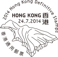
| Issue Date | 24.07.2014 |
| ID | Michel: Scott: Stanley Gibbons: Yvert: UPU: HK041.14 Category: Ot |
| Author | Shirman LAI |
| Stamps in set | 16 |
| Value | Low values: 10¢ - North Ninepin Island 20¢ - Basalt Island 50¢ - Tai Long Wan $1 - Po Pin Chau $1.70 - High Island Reservoir East Dam $2 - Port Island $2.20 - Wong Chuk Kok Tsui $2.30 - Bride’s Pool $2.90 - Lan Kwo Shui $3.10 - Lung Lok Shui $3.70 - Kang Lau Shek $5 - Ap Chau High values: $10 - Sharp Island $15.50 - High Island $20 - Lai Chi Chong $50 - Pak Sha Tau Tsui |
| Emmision | definitive |
| Places of issue | Hong Kong |
| Size (width x height) | Low values – 25 mm x 29 mm High values – 28.5 mm x 33.5 mm |
| Layout |
Low values – Pane of 100 stamps High values – Pane of 50 stamps |
| Products | FDC x3 |
| Paper | Paper with security fibres |
| Perforation | Low values – 13 x 13.75 (one elliptical perforation on each vertical) High values – 13.25 (one elliptical perforation on each vertical) |
| Print Technique | Lithography |
| Printed by | Joh. Enschedé B.V., the Netherlands |
| Quantity | |
| Issuing Authority | Hongkong Post |

On Jully 24th, the fourth set of definitive stamps issued by Hongkong Post since the establishment of the Hong Kong Special Administrative Region of the People’s Republic of China.
These stamps shows various Geo-Conservation landscapes of the country. One of these stamps (face value $2.20) shows some location well known as Devonian fossils found place in the country.
Hong Kong is an international metropolis of skyscrapers. On the outskirts of this bustling city, however, there lies a great expanse of countryside with opulent bio-diversity and a charming natural environment. Apart from providing habitats for our myriad wildlife, this verdant countryside is also rich in rare rock formations and world-class geological landscapes. Having exceptional geological environments and a wide variety of rocks, Hong Kong enjoys spectacular terrain with high conservation and appreciation value.
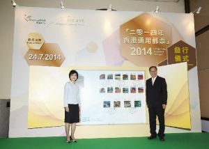 (From left) The Postmaster General, Mrs Jessie Ting, and the Director
of Agriculture, Fisheries and Conservation, Mr Alan Wong, officiates at
the "2014 Hong Kong Definitive Stamps" issuing ceremony.
(From left) The Postmaster General, Mrs Jessie Ting, and the Director
of Agriculture, Fisheries and Conservation, Mr Alan Wong, officiates at
the "2014 Hong Kong Definitive Stamps" issuing ceremony.
|
 Amidst the growing concern over geo-conservation
worldwide in recent years, Hong Kong Geopark was established to promote
geo-conservation and landscape protection. Hong Kong Geopark was
officially designated a member of the National Geopark of China in 2009
and was accepted as a member of the Global Geoparks Network in 2011,
renamed Hong Kong Global Geopark of China. Occupying a total area of
around 150 km2, the Geopark is divided into two regions, namely, Sai
Kung Volcanic Rock Region and Northeast New Territories Sedimentary
Rock Region. The former region comprises four Geo-Areas, i.e. High
Island, Sharp Island, Ung Kong Group and Ninepin Group, while the
latter also encompasses four Geo-Areas, i.e. Tung Ping Chau, Double
Haven, Tolo Channel and Bluff Head-Port Island. Sai Kung Volcanic Rock
Region is characterised by extensive polygonal acidic (mainly
pentagonal or hexagonal) volcanic rock columns, and Northeast New
Territories Sedimentary Rock Region features a range of sedimentary
rocks from different periods and rare landforms created from different
geological processes.
Amidst the growing concern over geo-conservation
worldwide in recent years, Hong Kong Geopark was established to promote
geo-conservation and landscape protection. Hong Kong Geopark was
officially designated a member of the National Geopark of China in 2009
and was accepted as a member of the Global Geoparks Network in 2011,
renamed Hong Kong Global Geopark of China. Occupying a total area of
around 150 km2, the Geopark is divided into two regions, namely, Sai
Kung Volcanic Rock Region and Northeast New Territories Sedimentary
Rock Region. The former region comprises four Geo-Areas, i.e. High
Island, Sharp Island, Ung Kong Group and Ninepin Group, while the
latter also encompasses four Geo-Areas, i.e. Tung Ping Chau, Double
Haven, Tolo Channel and Bluff Head-Port Island. Sai Kung Volcanic Rock
Region is characterised by extensive polygonal acidic (mainly
pentagonal or hexagonal) volcanic rock columns, and Northeast New
Territories Sedimentary Rock Region features a range of sedimentary
rocks from different periods and rare landforms created from different
geological processes.To deepen public understanding of the landscape features of Hong Kong and the importance of geo-conservation, Hongkong Post issues the Hong Kong Definitive Stamps 2014, a new set of definitive stamps showcasing the distinctive landforms and landscape of Hong Kong Global Geopark of China. There are altogether 16 denominations, namely:
10¢ - North Ninepin Island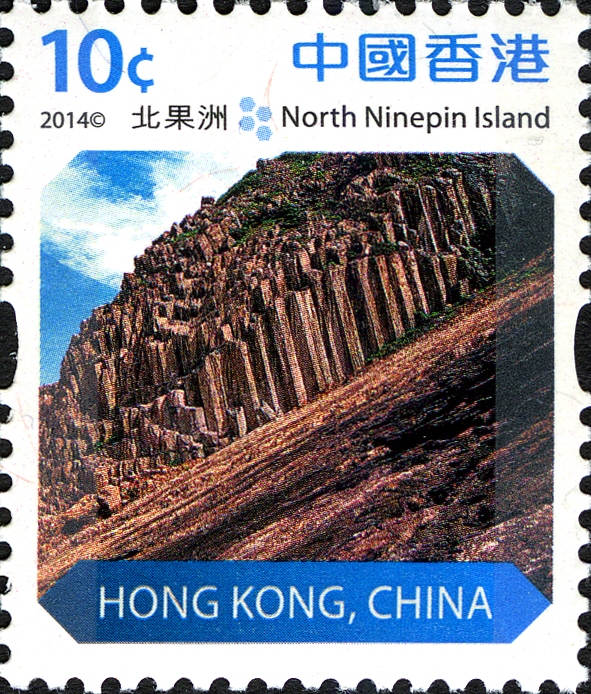 Situated in the open sea in the Ninepin
Group Geo-Area, North
Ninepin Island is an island made up basically of acidic volcanic rock
formed about 140 million years ago. Over millennia, wind and wave
erosion have created a variety of enchanting coastal landforms. There
are stunning hexagonal rock columns on the island, some of which have a
diameter of over two metres. Situated in the open sea in the Ninepin
Group Geo-Area, North
Ninepin Island is an island made up basically of acidic volcanic rock
formed about 140 million years ago. Over millennia, wind and wave
erosion have created a variety of enchanting coastal landforms. There
are stunning hexagonal rock columns on the island, some of which have a
diameter of over two metres. |
20¢ - Basalt Island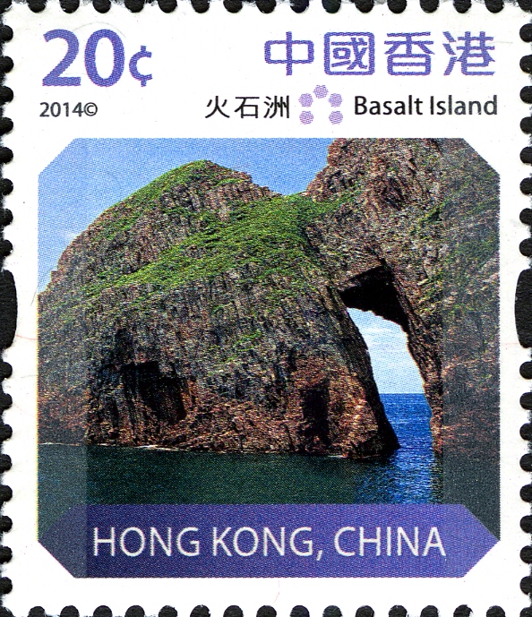 One of the islands in Ung Kong Group,
Basalt Island is comprised of
hexagonal rock columns formed around 140 million years ago. Continuous
wave action against the well-developed columnar joints of the rock
columns on the island caused them to erode into sea caves. When the
caves eventually enlarged and cut through, a rock bridge known as a
“sea arch” was formed. One of the islands in Ung Kong Group,
Basalt Island is comprised of
hexagonal rock columns formed around 140 million years ago. Continuous
wave action against the well-developed columnar joints of the rock
columns on the island caused them to erode into sea caves. When the
caves eventually enlarged and cut through, a rock bridge known as a
“sea arch” was formed. |
50¢ - Tai Long Wan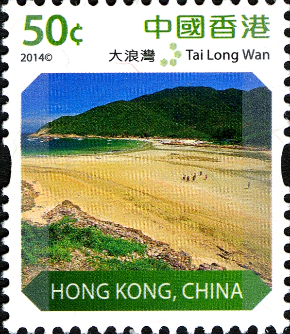 Tai Long Wan (Big Wave Bay) located in
the High Island Geo-Area
comprises four large adjoining beaches: Tung Wan, Tai Wan, Ham Tin Wan
and Sai Wan. In a wide stretch of open water, the distinctive sandy
beaches in Tai Long Wan, which are exposed to strong winds all year
long, were formed by the deposition of fine sand and shell fragments
transported to the inner bay by waves and currents. Tai Long Wan (Big Wave Bay) located in
the High Island Geo-Area
comprises four large adjoining beaches: Tung Wan, Tai Wan, Ham Tin Wan
and Sai Wan. In a wide stretch of open water, the distinctive sandy
beaches in Tai Long Wan, which are exposed to strong winds all year
long, were formed by the deposition of fine sand and shell fragments
transported to the inner bay by waves and currents. |
$1 - Po Pin Chau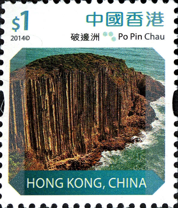 Situated in the High Island Geo-Area,
Po Pin Chau consists of hexagonal
rock columns formed about 140 million years ago. Originally a headland
of High Island extending to the sea, Po Pin Chau was eventually
separated from the main island by sustained coastal erosion, becoming
an enormous sea stack towering above the shore. The hexagonal rock
columns on Po Pin Chau stand in an almost upright position, resembling
a giant pipe organ. Situated in the High Island Geo-Area,
Po Pin Chau consists of hexagonal
rock columns formed about 140 million years ago. Originally a headland
of High Island extending to the sea, Po Pin Chau was eventually
separated from the main island by sustained coastal erosion, becoming
an enormous sea stack towering above the shore. The hexagonal rock
columns on Po Pin Chau stand in an almost upright position, resembling
a giant pipe organ. |
$1.70 - High Island
Reservoir East Dam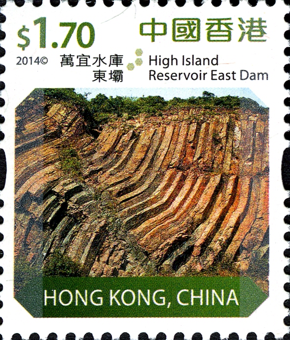 The High Island Reservoir East Dam is
nestled in the High Island
Geo-Area with groups of distinctive S-shaped rock columns, which were
formed about 140 million years ago when hot volcanic materials cooled
and contracted. Affected by the movement of the earth’s crust, the
semi-molten columns became deformed before they completely cooled down
and solidified. Subsequently, basaltic magma intruded into the columns,
forming a dark grey dyke. The High Island Reservoir East Dam is
nestled in the High Island
Geo-Area with groups of distinctive S-shaped rock columns, which were
formed about 140 million years ago when hot volcanic materials cooled
and contracted. Affected by the movement of the earth’s crust, the
semi-molten columns became deformed before they completely cooled down
and solidified. Subsequently, basaltic magma intruded into the columns,
forming a dark grey dyke. |
$2 - Port Island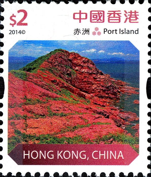 Port Island in the
Port Island-Bluff Head Geo-Area was formed from mostly reddish coarse
sandstone and conglomerate about 70 million years ago. As the Chinese
name Chek Chau implies, it is made up of red earth. The ferric-rich
deposits, which were extensively oxidised in the hot, dry and high
oxygen depositional environment, turned reddish brown, eventually
forming the red sedimentary rocks seen on Port Island today.
Port Island in the
Port Island-Bluff Head Geo-Area was formed from mostly reddish coarse
sandstone and conglomerate about 70 million years ago. As the Chinese
name Chek Chau implies, it is made up of red earth. The ferric-rich
deposits, which were extensively oxidised in the hot, dry and high
oxygen depositional environment, turned reddish brown, eventually
forming the red sedimentary rocks seen on Port Island today. |
$2.20 - Wong Chuk Kok Tsui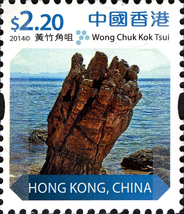 Wong Chuk Kok Tsui is located in the
Port Island-Bluff Head Geo-Area.
It has the oldest rocks in Hong Kong, including sandstone and
conglomerate formed around 400 million years ago, as proven by existing
fossil evidence,
is a bed of Devonian sedimentary rock. These rock strata
have been tilted and compressed into a more or less vertical position.
Further coastal erosion resulted in the formation of a peculiar rock
structure, such as the “Devil’s Fist”. The rich Devonian fossils
found in Tolo Channel provide a strong basis for determining geological
age and sequence stratigraphy. They also help us understand how Hong
Kong's natural environment evolved during that time. Wong Chuk Kok Tsui is located in the
Port Island-Bluff Head Geo-Area.
It has the oldest rocks in Hong Kong, including sandstone and
conglomerate formed around 400 million years ago, as proven by existing
fossil evidence,
is a bed of Devonian sedimentary rock. These rock strata
have been tilted and compressed into a more or less vertical position.
Further coastal erosion resulted in the formation of a peculiar rock
structure, such as the “Devil’s Fist”. The rich Devonian fossils
found in Tolo Channel provide a strong basis for determining geological
age and sequence stratigraphy. They also help us understand how Hong
Kong's natural environment evolved during that time. By analysing the sedimentation and living organisms of the Devonian in depth, we can see that the region around Plover Cove Reservoir on the northern shore of Tolo Channel today was primarily foreshore, river delta or inshore sedimentary shallow sea during the Early and Middle Devonian. Bivalvia, archaeostraca and conchostracan fossils have thus been discovered in this area. Fossils from the Late Devonian are mainly terrestrial primitive ferns. This indicates the sedimentary environment changed at this stage. The sea receded and land was exposed. Note: it is not a petrified wood, but a rock depicting on the stamp. |
$2.30 - Bride’s
Pool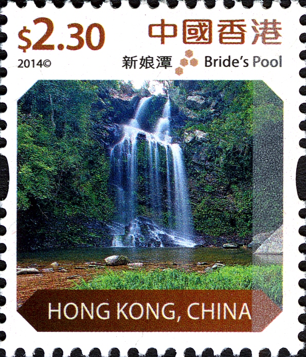 Nestled in the Double Haven Geo-Area,
Bride’s Pool is made up mainly of
sedimentary rocks dating back to about 100 million to 130 million
years. The name actually refers to the Plunge Pool at the bottom of the
Bride’s Pool Waterfall. Water falling from the top of the waterfall
eroded the rocks at its base, forming depressions. Further erosion by
abrasion and hydraulic action formed the deep plunge pool at the base
of the waterfall. Nestled in the Double Haven Geo-Area,
Bride’s Pool is made up mainly of
sedimentary rocks dating back to about 100 million to 130 million
years. The name actually refers to the Plunge Pool at the bottom of the
Bride’s Pool Waterfall. Water falling from the top of the waterfall
eroded the rocks at its base, forming depressions. Further erosion by
abrasion and hydraulic action formed the deep plunge pool at the base
of the waterfall. |
$2.90 - Lan Kwo Shui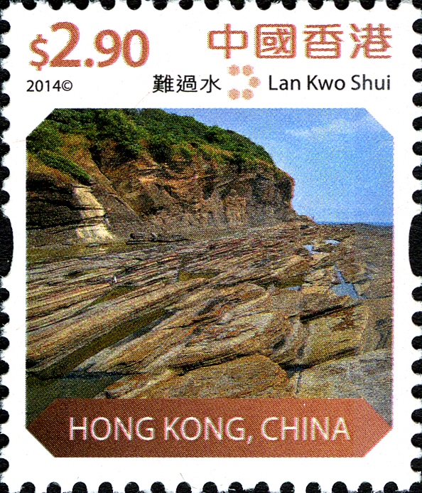 Lan Kwo Shui,
located in the Tung Ping
Chau Geo-Area, is composed mainly of sedimentary rocks dating back some
55 million years. After continuous erosion by destructive waves, the
base of the vertical sea cliff gradually receded, leaving behind a
narrow flat area, gently sloping and extending into the sea, called a
“wave-cut platform”, which is covered in water at high tide but exposed
at low tide, allowing it to be reached by foot. Lan Kwo Shui is so
named because it is difficult to reach much of the time.
Lan Kwo Shui,
located in the Tung Ping
Chau Geo-Area, is composed mainly of sedimentary rocks dating back some
55 million years. After continuous erosion by destructive waves, the
base of the vertical sea cliff gradually receded, leaving behind a
narrow flat area, gently sloping and extending into the sea, called a
“wave-cut platform”, which is covered in water at high tide but exposed
at low tide, allowing it to be reached by foot. Lan Kwo Shui is so
named because it is difficult to reach much of the time. |
$3.10 - Lung Lok Shui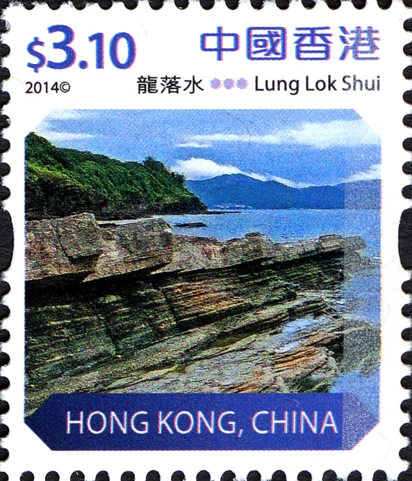 Situated on the central west bank of
Tung Ping
Chau, the renowned scenic spot Lung Lok Shui is a wide layer of unusual
siliceous rock 100m long and about 0.8m thick, tilted towards the sea.
From a bird’s eye view, the exposed siliceous rock visible above ground
on the shoreline looks like a giant dragon rising from the water, hence
earning its name, which means “dragon diving into the sea”. This
landform demonstrates typical differential weathering and erosion. Situated on the central west bank of
Tung Ping
Chau, the renowned scenic spot Lung Lok Shui is a wide layer of unusual
siliceous rock 100m long and about 0.8m thick, tilted towards the sea.
From a bird’s eye view, the exposed siliceous rock visible above ground
on the shoreline looks like a giant dragon rising from the water, hence
earning its name, which means “dragon diving into the sea”. This
landform demonstrates typical differential weathering and erosion. |
$3.70 - Kang Lau
Shek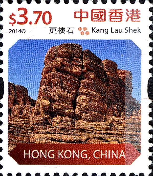 Located in the
easternmost corner of Tung
Ping Chau, Kang Lau Shek is made up primarily of thinly laminated
siltstone, formed about 55 million years ago. Affected by constant
coastal erosion, the sea-arch once situated here eroded gradually and
finally collapsed, leaving behind two sea stack formations, known as
Kang Lau Shek (Watchtower Stones) because they look like the
watchtowers of an ancient village. Located in the
easternmost corner of Tung
Ping Chau, Kang Lau Shek is made up primarily of thinly laminated
siltstone, formed about 55 million years ago. Affected by constant
coastal erosion, the sea-arch once situated here eroded gradually and
finally collapsed, leaving behind two sea stack formations, known as
Kang Lau Shek (Watchtower Stones) because they look like the
watchtowers of an ancient village. |
$5 - Ap Chau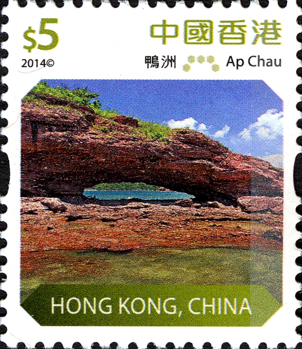 Featuring a diverse range of wave-cut
landforms, Ap
Chau in the Double Haven Geo-Area offers a vista of red breccia, rare
in Hong Kong, formed 70 to 90 million years ago. Duck’s Eye, a famous
sea arch on the island, was formed by differential erosion – the
difference in resistance or susceptibility of various rock types to
wave erosion. Featuring a diverse range of wave-cut
landforms, Ap
Chau in the Double Haven Geo-Area offers a vista of red breccia, rare
in Hong Kong, formed 70 to 90 million years ago. Duck’s Eye, a famous
sea arch on the island, was formed by differential erosion – the
difference in resistance or susceptibility of various rock types to
wave erosion. |
$10 - Sharp Island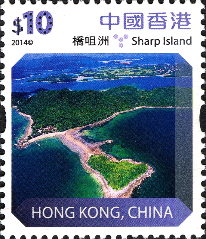 Sharp Island is an elongated
island, formed
some 143 million years ago. Various types of volcanic rocks including
volcanic breccia, quartz monzonite and rhyolite, can be found on the
island. A natural sand bar connects Sharp Island with the neighbouring
Kiu Tau Island at low tide. At high tide this is submerged, leaving Kiu
Tau as a small isolated island. In geology, this coastal deposition is
known as a “tombolo”
Sharp Island is an elongated
island, formed
some 143 million years ago. Various types of volcanic rocks including
volcanic breccia, quartz monzonite and rhyolite, can be found on the
island. A natural sand bar connects Sharp Island with the neighbouring
Kiu Tau Island at low tide. At high tide this is submerged, leaving Kiu
Tau as a small isolated island. In geology, this coastal deposition is
known as a “tombolo” |
$15.50 - High Island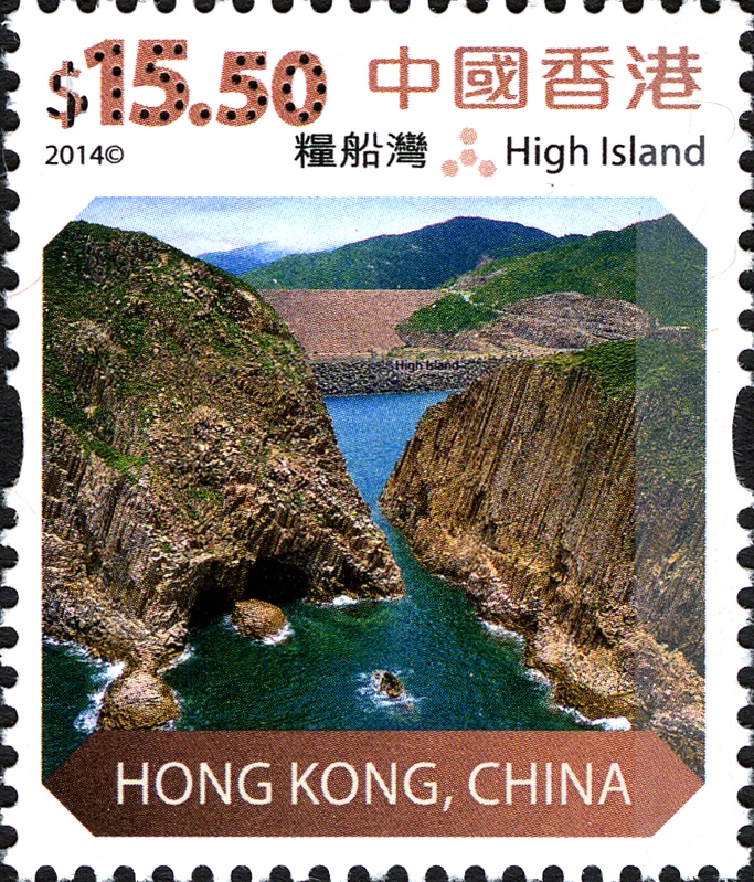 High Island, in Sai Kung East Country
Park, is
made up primarily of acidic volcanic rocks. About 140 million years
ago, an extremely violent volcanic eruption occurred in the area, which
resulted in the deposition of a hot volcanic mass that slowly cooled
and condensed, forming the enormous hexagonal rock columns we see
today. Other geological features observable on High Island include
faults, folds and dyke intrusions formed by condensation of magma which
penetrated into the joints. High Island, in Sai Kung East Country
Park, is
made up primarily of acidic volcanic rocks. About 140 million years
ago, an extremely violent volcanic eruption occurred in the area, which
resulted in the deposition of a hot volcanic mass that slowly cooled
and condensed, forming the enormous hexagonal rock columns we see
today. Other geological features observable on High Island include
faults, folds and dyke intrusions formed by condensation of magma which
penetrated into the joints. |
$20 - Lai Chi Chong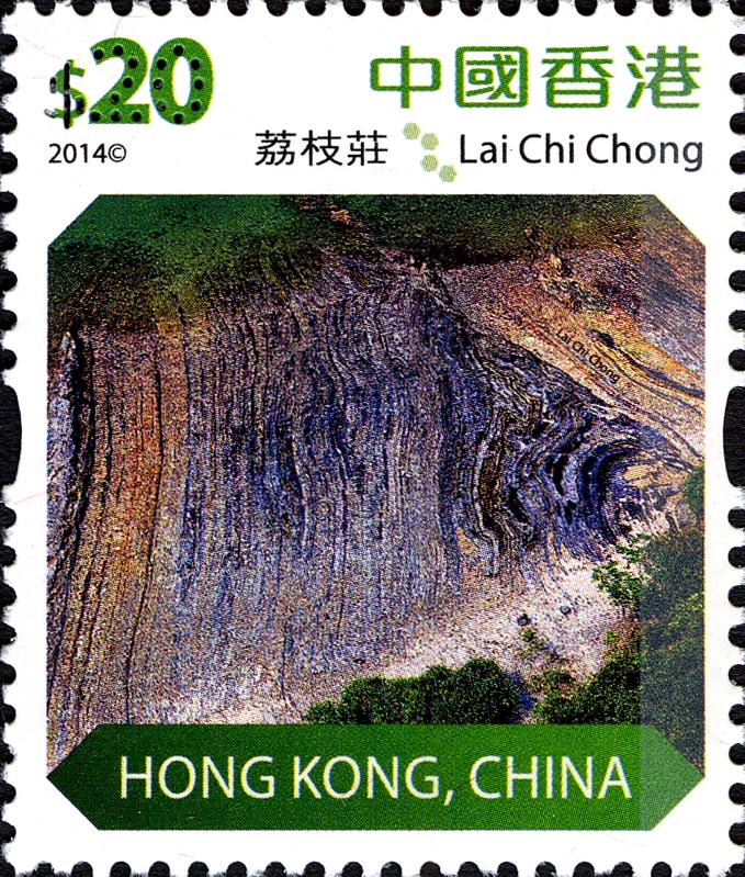 Composed mainly of volcanic sedimentary
rock,
Lai Chi Chong in the Tolo Channel Geo-Area was formed about 150 million
years ago and features the most characteristic geological setting in
Hong Kong. Tectonic movements caused the sedimentary rock strata here
to become compressed and deformed, creating a breathtaking,
surrealistic landscape, like a painting. Composed mainly of volcanic sedimentary
rock,
Lai Chi Chong in the Tolo Channel Geo-Area was formed about 150 million
years ago and features the most characteristic geological setting in
Hong Kong. Tectonic movements caused the sedimentary rock strata here
to become compressed and deformed, creating a breathtaking,
surrealistic landscape, like a painting. |
$50 - Pak Sha Tau Tsui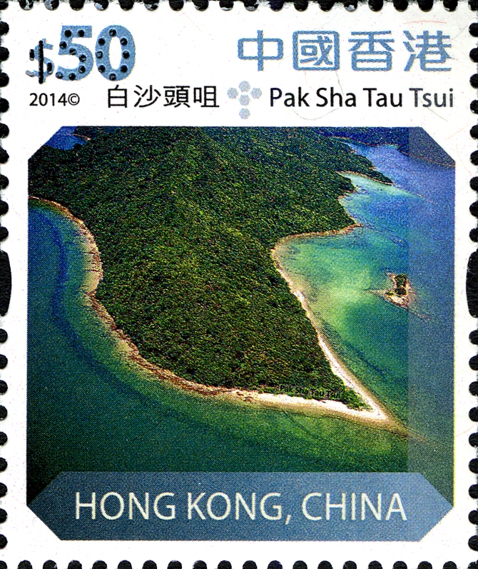 Lying in the Double
Haven Geo-Area,
Pak Sha Tau Tsui is a sand spit below Wong Fong Shan, resembling an
exposed ink brush pointing to the southwest at low tide. Tidal flow has
deposited sand and shell fragments at the headland, where the currents
meet. It is one of the famous “six treasures of Double Haven” – the
“Ink Brush”.
Lying in the Double
Haven Geo-Area,
Pak Sha Tau Tsui is a sand spit below Wong Fong Shan, resembling an
exposed ink brush pointing to the southwest at low tide. Tidal flow has
deposited sand and shell fragments at the headland, where the currents
meet. It is one of the famous “six treasures of Double Haven” – the
“Ink Brush”. |
Stamp products include mint stamps, stamp sheets, souvenir sheets, presentation pack, definitive stamp booklets, reel stamps and postcards. Maximum cards and serviced first day covers are also available at the philatelic offices on the issue day only.
References: Hong Kong Post Stamps
| <prev |
|
Last update 20.01.2018
Any feedback, comments or even complaints are welcome: admin@paleophilatelie.eu (you can email me on ENglish, DEutsch, or RUssian)